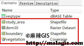
现在,越来越多的组织和个人选择使用 Geodatabase 格式来组织其空间数据。下面我们将学习如何将已有的数据导入 Geodatabase 空间数据空中。 示例数据在…\DATA\BuildingGeodatabase 中,该文件夹中的内容是某保护区的地形及植被信息,还有该保护区的范围以及研究区域范围。我们的练习目的是要在该文件夹中创建一个 Geodatabase, 将所有数据转换为 Geodatabase 格式。

创建空间数据
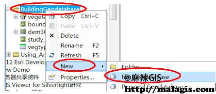
(1) 在 ArcCatalog 中定位到…\DATA\BuildingGeodatabase,右键单 击 BuildingGeodatabase —> New —> File Geodatabase,创建 Geodatabase。


(2) 点击工具栏上的红色工具箱,打开 ArcToolbox。定位到 ArcToolbox
—> Conversion Tools —> To Geodatabase —> Feature Class to Feature Class 工具,双击打开此工具。

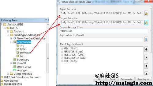
(3) 在弹出的 feature class to feature class 工具窗口中, Input Features 项 填 入…\DATA\BuildingGeodatabase\vegetation\polygon;Output Location 项填入 …\DATA\BuildingGeodatabase\New File Geodatabase.gdb;Output Feature Class 项填入 vegetation。点 击 OK,即可开始入库格式转换。工具运行是在后台进行,转换完成 后,会在显示器右下角弹出处理结果![]() 。
。

上述操作是将 coverage 格式的 vegetation 中的 polygon 转换为 Geodatabase 格式的数据,存储在第一步新建的 Geodatabase 中,转换后的 新要素类名称为 vegetation。使用该工具不仅能够转换 coverage 格式的数据,还能够将 shapefile 或者 CAD 的数据转换为 Geodatabase 格式。
(4) 使用上述相同的方法(Feature Class to Feature Class 工具), 将 …\DATA\BuildingGeodatabase\boundary.shp 和 study_area.shp 分别转化为 Geodatabase 格式,导入 New File Geodatabase.gdb 中。
栅格数据入库
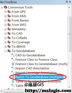
(1) 定位到 ArcToolbox —> Conversion Tools —> To Geodatabase—> Raster To Geodatabase(multiple)工具,双击将其打开。

(2) Input Rasters 项填入…\DATA\BuildingGeodatabase\dem30; Output Geodatabase 项 填 入…\data\BuildingGeodatabase\New File Geodatabase.gdb, 点击 OK 即可将栅格数据 dem30 导入到 Geodatabase 中。

(3) 若还有更多栅格数据,需要拼接为一幅图存储,则可在已导入栅格的基础上进行数据追加。对第 2 步已导入 Geodatabase 的 dem30 右键 —> Load —>Load Data,即可开始栅格图幅的拼接工作。


